
Riding the Dalton Highway
The Road to Prudhoe Bay: An Excerpt from The Adventurous Motorcyclist's Guide to Alaska
Enter the Alaskan expanse on the northern-most road in North America: the Dalton Highway. This steadily plodding pathway charts a lonely route through three different geologic regions: the forested sub-alpine Interior, the mountainous Brooks Range, and the tundra-covered Arctic Coastal plain. Find more maps routes, accommodation lists, and essential tips for the Dalton Highway and many other Alaskan routes in The Adventurous Motorcyclist's Guide to Alaska.
The road to Prudhoe Bay consists of 414 schizophrenic miles of dirt and tarmac that can be as smooth as a polished bowling ball or as beat to hell as a West Virginia bar-brawler’s nose. Built in 1974 to allow semi trucks to service the oil refinery at Prudhoe Bay, the road crosses a vast expanse of wilderness that includes the Brooks Range, the Arctic National Wildlife Refuge, Gates of the Arctic National Park, and a monstrous expanse of Arctic tundra. On the north end of the road in midsummer, temperatures average 37 degrees and daylight is a 24-hour affair.
On the road, you’ll encounter traffic as erratic as the conditions, as 90-mile-per-hour ice road truckers, enterprising RV drivers from around the world, crazy motorcyclists, and even crazier bicyclists blast past, all hell-bent to drive as far north as possible in North America.
If the weather is good and the surface in great shape, the ride’s challenges of dodging trucks and potholes are manageable. On a sunny day, you might see high temperatures in the 60s and blue sky above. If you hit inclement weather, as most do, or make a mistake, you are in for a much more challenging adventure. The surface is slick when wet, and temperatures on the Dalton can drop below freezing even in the heart of summer. One thing is for certain: Riding the Dalton is an essential feat for the serious motorcycle adventurer.
The mix of midnight sun and interesting geography is more compelling than the road itself, which is a mix of well-maintained gravel and chip seal (essentially pavement). People who’ve ridden the road love to tell horror stories about deep gravel and horrific potholes, but a decent rider on an adventure bike can easily meet the technical challenges of the road provided they stay off the treacherous shoulders. The road is passable by skilled riders on large adventure bikes; it is hellish on cruisers but can be done.
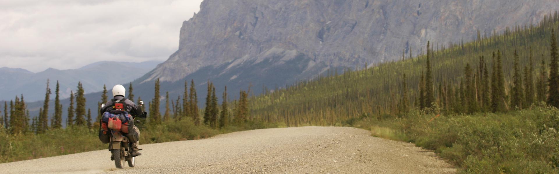
 The Dalton Highway is one of the most remote stretches of road in North America. This is the view going south toward the 4,459-foot Sukakpak Mountain (mile 204). The area has almost no cell service and a tow truck or emergency vehicle will take hours or even days to reach you. Photo courtesy of MotoQuest / Header photo courtesy of Lee Klancher
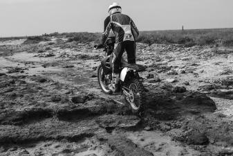
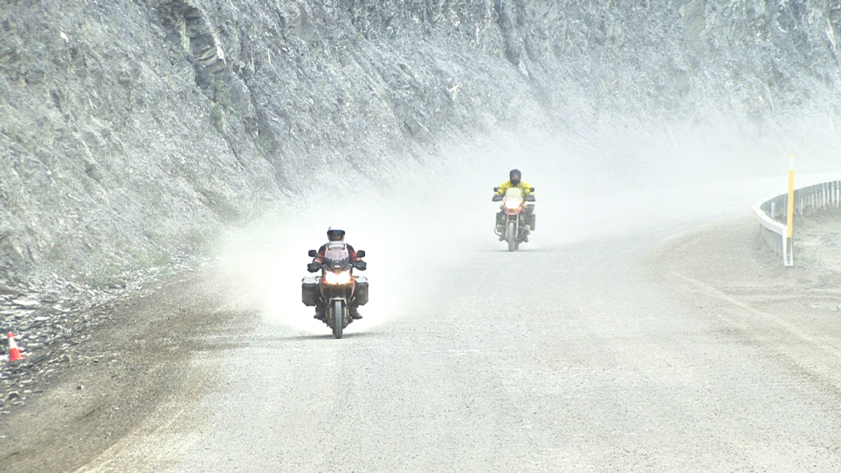 The Dalton surface gets very dusty and beaten up. Expect sections to be rough and nasty, and remember the surface becomes very slick when it rains or snows. Photo courtesy of MotoQuest
One of the road’s biggest challenges is complacency. Don’t drift off the hard-packed center. Those soft shoulders will suck you in quick, and toss you and your bike into the bush. Be particularly wary of this when trucks pass you. The truckers literally own the road and cover it at speeds up to 90 miles per hour. Let them by, but take care to avoid those soft shoulders.
Be warned that trucks going past you will spray you with rocks, some fist-sized. Duck under your windshield and be prepared to take a few hits to your bike. Incidentally, if your bike is a pristine queen and you want it to stay that way, don’t ride it on the Dalton. The surface turns to liquid concrete when it’s wet and will cover your bike with goo that becomes permanent if it hardens. And the rocks will pound dents and dings into paint and chrome.
One of the unique facets of the “Haul Road,” as it’s called, is that it is almost always on fire. Lightning strikes commonly cue modest wildfires that are spread by the typically windy summer weather. The fires smolder and occasionally burst a spruce into flame, but the swamp land rarely permits fires of any size to take hold.
As you ride the road, you are likely to pass through one of these smoldering areas, and possibly drive by a flaming spruce. The fires are not usually dangerous. Visibility can be obscured by smoke, however, and you need to take extreme caution when riding blind.
People love to stop in the middle of the road to take a photo, which is generally about the time two trucks come hauling butt down the road from each direction, ready and willing to make an trucker sandwich out of you and your bike. When you stop, pull well off the road but NOT on the soft shoulders. The Alyeska Pipeline access points are good places to stop.
The bugs are absolutely horrific on the Dalton. Mosquito nets and a heavy dousing of good-quality bug spray are necessary—the size and ferocity of the bugs are quite probably the worst you’ll encounter anywhere on the continent. You can get away from them on top of knolls or on a riverside with a big gravel bar. (Phil has checked this out thoroughly as he loves to nap alongside the road.)
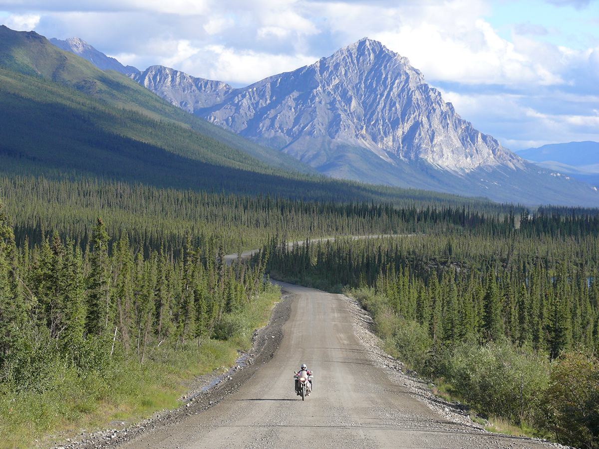
 The Dalton Highway crosses the Brooks Range at the 4,739-foot Atigun Pass (mile 244). Photo courtesy of MotoQuest
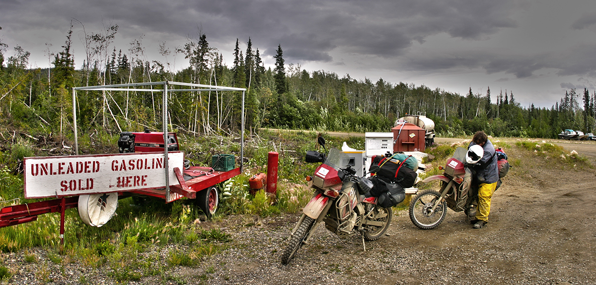 The gas stop at the Hot Spot Café (mile 61) is simple, to say the least. It’s also not always open. Gas is available a few miles back toward Fairbanks at Yukon River Camp. Lee Klancher
Riding the road was once a feat of great daring. The early accounts of those who braved the route were fraught with ice, snow, and peril. Perhaps the greatest danger riders faced was the cold. Gear in the 1970s simply wasn’t anywhere near what we have now, and the addition of electrically heated gear has made cold weather much easier to tolerate. The road itself may have been in a bit worse condition back in the day, but the dangers typical of the old accounts were driven mainly by the fact that the road was rarely ridden.
One of the first riders to cover the highway was John Binkley, who had his BMW loaded into an Hercules cargo plane and flown to Prudhoe Bay. He did this on December 1, 1975, and the temperature was 35 below zero. He rode bundled in double parkas and, judging from the list on his website, every other piece of clothing he owned. He rode south and, in fact, continued all the way to Ushaia at the tip of South America. Binkley’s ride was extremely dangerous, given the cold and the conditions. Traveler Doris Wiedemann, among others, also rode the Dalton in the winter.
The key to appreciating the adventurous nature of the Dalton is to understand you are entering the wilds. That lonely strip of road cuts across a vast wilderness comprising Alaska’s northern half—roughly 300,000 square miles that are virtually uninhabited.
That area is roughly the size of Texas and larger than the combined square mileage of America’s smallest 15 states. You’ll cross three distinct geologic areas: the forested sub-alpine Interior, the mountainous Brooks Range, and the tundra-covered Arctic Coastal plain known as the North Slope.
The vastness of this wilderness area is hard to fathom, even for riders accustomed to crossing the Great Plains or the vast expanses of the American Southwest. The miles and miles of wilderness stretching around you while riding the Dalton will give you a sense of that.
Read more about Alaska's most dramatic passageways, including the Denali Highway, the Richardson Highway, the George Parks Highway, and many more. The Adventurous Motorcyclist's Guide to Alaska is packed with maps, routes, accomodation lists, and essential tips for the journey.
The road to Prudhoe Bay consists of 414 schizophrenic miles of dirt and tarmac that can be as smooth as a polished bowling ball or as beat to hell as a West Virginia bar-brawler’s nose. Built in 1974 to allow semi trucks to service the oil refinery at Prudhoe Bay, the road crosses a vast expanse of wilderness that includes the Brooks Range, the Arctic National Wildlife Refuge, Gates of the Arctic National Park, and a monstrous expanse of Arctic tundra. On the north end of the road in midsummer, temperatures average 37 degrees and daylight is a 24-hour affair.
On the road, you’ll encounter traffic as erratic as the conditions, as 90-mile-per-hour ice road truckers, enterprising RV drivers from around the world, crazy motorcyclists, and even crazier bicyclists blast past, all hell-bent to drive as far north as possible in North America.
If the weather is good and the surface in great shape, the ride’s challenges of dodging trucks and potholes are manageable. On a sunny day, you might see high temperatures in the 60s and blue sky above. If you hit inclement weather, as most do, or make a mistake, you are in for a much more challenging adventure. The surface is slick when wet, and temperatures on the Dalton can drop below freezing even in the heart of summer. One thing is for certain: Riding the Dalton is an essential feat for the serious motorcycle adventurer.
The mix of midnight sun and interesting geography is more compelling than the road itself, which is a mix of well-maintained gravel and chip seal (essentially pavement). People who’ve ridden the road love to tell horror stories about deep gravel and horrific potholes, but a decent rider on an adventure bike can easily meet the technical challenges of the road provided they stay off the treacherous shoulders. The road is passable by skilled riders on large adventure bikes; it is hellish on cruisers but can be done.
The Dalton Highway is one of the most remote stretches of road in North America. This is the view going south toward the 4,459-foot Sukakpak Mountain (mile 204). The area has almost no cell service and a tow truck or emergency vehicle will take hours or even days to reach you. Photo courtesy of MotoQuest / Header photo courtesy of Lee KlancherThe Dalton surface gets very dusty and beaten up. Expect sections to be rough and nasty, and remember the surface becomes very slick when it rains or snows. Photo courtesy of MotoQuestOne of the road’s biggest challenges is complacency. Don’t drift off the hard-packed center. Those soft shoulders will suck you in quick, and toss you and your bike into the bush. Be particularly wary of this when trucks pass you. The truckers literally own the road and cover it at speeds up to 90 miles per hour. Let them by, but take care to avoid those soft shoulders.
Be warned that trucks going past you will spray you with rocks, some fist-sized. Duck under your windshield and be prepared to take a few hits to your bike. Incidentally, if your bike is a pristine queen and you want it to stay that way, don’t ride it on the Dalton. The surface turns to liquid concrete when it’s wet and will cover your bike with goo that becomes permanent if it hardens. And the rocks will pound dents and dings into paint and chrome.
One of the unique facets of the “Haul Road,” as it’s called, is that it is almost always on fire. Lightning strikes commonly cue modest wildfires that are spread by the typically windy summer weather. The fires smolder and occasionally burst a spruce into flame, but the swamp land rarely permits fires of any size to take hold.
As you ride the road, you are likely to pass through one of these smoldering areas, and possibly drive by a flaming spruce. The fires are not usually dangerous. Visibility can be obscured by smoke, however, and you need to take extreme caution when riding blind.
People love to stop in the middle of the road to take a photo, which is generally about the time two trucks come hauling butt down the road from each direction, ready and willing to make an trucker sandwich out of you and your bike. When you stop, pull well off the road but NOT on the soft shoulders. The Alyeska Pipeline access points are good places to stop.
The bugs are absolutely horrific on the Dalton. Mosquito nets and a heavy dousing of good-quality bug spray are necessary—the size and ferocity of the bugs are quite probably the worst you’ll encounter anywhere on the continent. You can get away from them on top of knolls or on a riverside with a big gravel bar. (Phil has checked this out thoroughly as he loves to nap alongside the road.)
The Dalton Highway crosses the Brooks Range at the 4,739-foot Atigun Pass (mile 244). Photo courtesy of MotoQuestThe gas stop at the Hot Spot Café (mile 61) is simple, to say the least. It’s also not always open. Gas is available a few miles back toward Fairbanks at Yukon River Camp. Lee KlancherRiding the road was once a feat of great daring. The early accounts of those who braved the route were fraught with ice, snow, and peril. Perhaps the greatest danger riders faced was the cold. Gear in the 1970s simply wasn’t anywhere near what we have now, and the addition of electrically heated gear has made cold weather much easier to tolerate. The road itself may have been in a bit worse condition back in the day, but the dangers typical of the old accounts were driven mainly by the fact that the road was rarely ridden.
One of the first riders to cover the highway was John Binkley, who had his BMW loaded into an Hercules cargo plane and flown to Prudhoe Bay. He did this on December 1, 1975, and the temperature was 35 below zero. He rode bundled in double parkas and, judging from the list on his website, every other piece of clothing he owned. He rode south and, in fact, continued all the way to Ushaia at the tip of South America. Binkley’s ride was extremely dangerous, given the cold and the conditions. Traveler Doris Wiedemann, among others, also rode the Dalton in the winter.
The key to appreciating the adventurous nature of the Dalton is to understand you are entering the wilds. That lonely strip of road cuts across a vast wilderness comprising Alaska’s northern half—roughly 300,000 square miles that are virtually uninhabited.
That area is roughly the size of Texas and larger than the combined square mileage of America’s smallest 15 states. You’ll cross three distinct geologic areas: the forested sub-alpine Interior, the mountainous Brooks Range, and the tundra-covered Arctic Coastal plain known as the North Slope.
The vastness of this wilderness area is hard to fathom, even for riders accustomed to crossing the Great Plains or the vast expanses of the American Southwest. The miles and miles of wilderness stretching around you while riding the Dalton will give you a sense of that.
Read more about Alaska's most dramatic passageways, including the Denali Highway, the Richardson Highway, the George Parks Highway, and many more. The Adventurous Motorcyclist's Guide to Alaska is packed with maps, routes, accomodation lists, and essential tips for the journey.
Related Books

Journey to the End of the World
Adventurous Motorcyclists Guide to Alaska
Forward